
Every 10 years or so, port administrators dust off their crystal ball to produce a new port master plan. The idea is to review and document how the port is doing, give port’s stakeholders voice on what they expect from the port, and agree on what would enable the port to succeed in the future. A port master plan is not just about expanding and constructing new infrastructure, which nowadays can be stemmed by local stakeholders’ resistance to expansion. Factors including emissions impact on adjacent urban and residential areas, environmental constraints, and an increased transport moves throughout port’s hinterland are also taken into master planning consideration.
The resulting document is a joint communiqué outlining both current and future developments in and around the port and the rationale for doing that, usually based on trade predictions that will increase volumes of cargo handled by the port.
Why all the people?
It’s a legacy of how port master planning has been done for decades. Port master planning provide various stakeholders with a good opportunity to express their views. Engaging infrastructure engineering company provides inputs in all kinds of engineering discussions that arise out of port modernisation or expansion aspirations.
Why every 10 years (or so)?
Because it is inefficient to bring more often together all port stakeholders to debate and decide on something that will bear fruit after decades. Capital projects outlined in a typical master plan will take about five years to realise and another 10-20 years to prove their value. Refreshing master plan every 10 years or so also avoids inevitable economic fluctuations in the short and medium term. Port master plans are generally optimistic documents rationalising major capital works either to renovate or to expand the port. A 10+ year horizon allows to show growth and disregard downturn events which could inevitably occur in near and medium term.
The problem of current plans is that they must compromise between multiple time horizons. A Plan-to-Commercially Operate period for a bulk terminal may be 10 years. That’s long enough period for the industry needing particular commodity flowing through that terminal to downsize, move or disappear all together.
An update of the port master plan is always a result of stakeholders’ perception that the demand for the port to be there and its services is changing or worse, has actually already changed and the port became an underperforming bottleneck for the regional growth. The changes may be coming from changes to the industrial capacity in port’s hinterland, different mix of commodities shipped through, different packaging of those commodities (boxed/bulk), different type of ships that the carriers send to serve those trades. By necessity, modelling demand scenarios against the port needs is simple. E.g. if hinterland demand (due to estimated population growth) for grain increases, will the port see more handymaxes or fewer, but larger panamaxes? The former calls for better organization of the port.
The latter calls for planning of deeper channels and basins (dredging $$) and maybe stronger berths (engineering $$). Can one believe that most of those “what if” guesses are still made in Excel spreadsheets?
More progressive master port planning consultants created their own simulation models allowing stakeholders to better understand how one asset (e.g. port) might react to change in another asset (more port access roads). Those simulations are not able to answer how the (re)design might behave/perform over time in the real-world. Its main purpose is to recreate an object, process or a system – not take the object and project it into the future.
Employ a machine
At the core of this decision lies creation of a digital representation of the physical entity: the port and its hinterland, which adds the time dimension to the analysis. In ports, this is achieved with twinning the digital model of the port and its assets with sensors providing the model with up-to-date data on conditions affecting each asset. Large entities, like a port and the market that surrounds, can function as separate digital twins including data on their respective configuration and mutual interaction. That’s the proper way to account for the entire design-execute-change-decommission lifecycle, while obtaining actual, not simulated, usage/performance data.
Since we are talking about infinitely more data that can ever be handled by an Excel-based model, the digital platform can virtually strengthen existing or build new infrastructure and keep testing that asset against data changing over time.
Let’s bring it to life using the simplest of the planning problems. Based on inland demand trend assessment for imported commodities, you determined that bulk terminal (A) will be handling twice as much cargo in the 10 year time span of the master plan. The terminal is located between 2 container terminals. Would you like to plan with visual ideas and static data (picture left) or with static and sensor-generated dynamic data (picture right)?
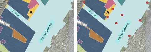
Master this part of the plan with Excel/possibly simulation software and static data: (1) how will the supply chains utilize the terminal? (2) should the area of the terminal become larger? (3) will the berth handle twice as many handymaxes without causing demurrage? (4) if shippers start using panamaxes, is the berth strength sufficient to moor larger vessels? (5) is the wave from passing container vessels going to affect moored vessels and call for different mooring engineering solution? (6) should the channel be dredged deeper and by how much? (7) should the channel be made wider to allow for vessels passing in the channel and will that affect the residential shore defences? (8) should we even have a bulk terminal in this part of the port or should we look for a new location with comparable/better intermodal and truck access? (9) what’s the cost estimate if all or some needs to be done?
Without a digital twin rerunning all interconnected scenarios using dataset created from IoTs on the water, in the berth walls/piles, on the opposite residential shore and on the land (railtrack and road sensors), hitting on a correct solution for the next 10 years is not possible.
Considering the fact that digital twin platforms can have the potential to extrapolate future and near scenarios from any point in time, the master port planning ex machina can become totally different to the typical option available to port stakeholders today. If you are master (re)planning your port, are you planning for connected sensing infrastructure too?
Surprisingly, very few ports today expand in their master plans on how they leverage digital technology to plan and operate. Usually, only one or two sentences are dedicated to such subject. Don’t take my word for it. Check it out yourself, as the plans for major ports are available on-line.
The digital twinning technology is entirely unique due to its ability to recreate how each duplicated component of the port will interact with other digital twins, even on the same platform. The port/city/region merges with its supply chain processes because one doesn’t exist without the other. You owe to your planning team to consider getting this digital planner on board.
Do you see port master planning becoming very different from how it is done today?